
Budapest Danube River
Stay updated with real-time Danube water levels, flow, temperature, flood warnings, and forecasts for Budapest. Essential for locals, tourists, and river cruises.
Water Levels Today
The current water level in the city center of Budapest is 33 cm, last recorded on 10/18/2026.
This chart provides hourly updates of water levels in centimeters for the Danube River in Budapest. The blue line shows data from the past year, while the gray line represents the same period last year. This is perfect for spotting trends and seasonal changes.The current water flow in Budapest is 843.2 m3/s and the temperature today is 16.2 Celsius.
The water levels in the Danube are generally unpredictable, but the river usually experiences moderate changes, making it a great location for cruising.
Temperature and Flow
This chart displays the water temperature and flow rate of the Danube River in Budapest, measured in cubic meters per second (m³/s).10 Hour Trend
Get hour-by-hour updates on water levels over the past 10 hours, providing a clear view of recent changes in the Danube's conditions.
| 14:00 | 33 cm 0% |
| 15:00 | 34 cm 3.03% |
| 16:00 | 34 cm 0% |
| 17:00 | 34 cm 0% |
| 18:00 | 34 cm 0% |
| 19:00 | 34 cm 0% |
| 20:00 | 35 cm 2.94% |
| 21:00 | 33 cm -5.71% |
| 22:00 | 35 cm 6.06% |
| 23:00 | 35 cm 0% |
Flood Alerts
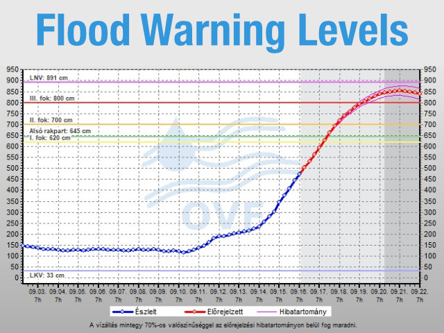
The Danube River in Budapest has specific flood warning levels. These are set by the Hungarian water authorities to help monitor and manage potential flooding.
The alerts are determined by the water height at the Budapest gauge near the Chain Bridge. For the most up-to-date graphs and forecasts, visit the HYDROINFO website. You can also watch the Danube in real-time through the Budapest webcam feeds.
Level 1: Yellow Alert
A yellow alert (Flood Preparedness) is issued when the water level reaches 620 cm (6.2 meters). This is the first warning, and authorities start monitoring the river and preparing for possible flooding.
Level 2: Orange Alert
The orange alert (Moderate Flood Risk) is triggered when the water reaches 700 cm (7.0 meters). At this stage, low-lying areas along the riverbanks may start to flood, and authorities may put up temporary flood barriers.
Level 3: Red Alert
A red alert (Severe Flood Risk) is issued when the water level reaches 800 cm (8.0 meters). This is the most serious warning, with full flood defenses in place, and evacuations of at-risk areas may be considered to keep people safe.
Lower Embankment
The "alsó rakpart" is the lower embankment along the Danube in Budapest. When the water reaches 645 cm, it can flood the roads and pathways along the riverbanks, often leading to closures.
Record Water Level
LNV stands for "Legnagyobb Vízoszlop", which is Hungarian for "highest water column." It is the highest water level ever recorded on the Danube in Budapest: 891 cm. This record was set during the great flood of June 2013 and serves as a key reference point for all other measurements.
River Facts
Budapest is cut in half by the Danube river, which separates the hilly Buda district on the west bank from the flat Pest district on the east bank.
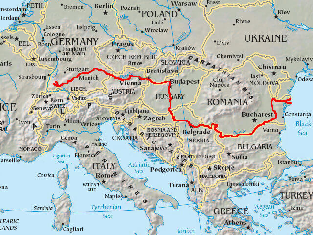
The Danube is Europe's second-longest river and flows through 10 countries from Germany's Black Forest to the Black Sea. In Budapest, it is crossed by several beautiful bridges, including the iconic Chain Bridge.
Highs and Lows
Low water levels typically happen at the end of a hot summer, while high water levels usually occur during the spring. This is because melting snow from the mountains causes rivers to carry extra water to the Danube.
River Cruises
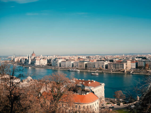
Whether you are looking for a romantic dinner cruise or a sightseeing tour, Budapest has many options for cruising on the Danube. Many of the city's most famous landmarks, such as the Hungarian Parliament Building, the Fisherman's Bastion, and Buda Castle, can be seen from the water, making a river cruise a great way to experience the city's beauty.
Fun Facts
- Music: The Danube is so famous it has its own song! The "Blue Danube" waltz was composed by Johann Strauss II and is one of the most well-known pieces of classical music ever written.
- Wildlife: The river is full of life, with over 35 different species of fish found in the waters around Budapest. Protected species like the striped ruffe and the white-finned gudgeon live here.
- History: Ancient Romans once used the Danube as a border for their huge empire. Today, four capital cities (Vienna, Bratislava, Budapest, and Belgrade) sit along its banks.
How Deep Is the Danube in Budapest?
In Budapest, the Danube is typically between 3 and 10 meters deep, depending on the season and the current water level. After dry summers the river can get much shallower, while spring snowmelt from the mountains makes it deeper.
Depth matters most for shipping: the navigable channel of the Danube is maintained to a minimum of about 2.5 meters so that river cruises and cargo ships can pass safely. When you check the water level above, remember that the gauge reading in centimeters is measured against a fixed reference point near the Chain Bridge, not the actual river depth.
Water Level Map & Gauging Station
The official water level measurements for Budapest are taken near the Széchenyi Chain Bridge. This map shows the location of the gauging station.